

WEEKEND WEATHER 4/7/25 Heavy
rainfall and high winds swept through Clay County over the weekend, breaking
tree limbs, bringing down powerlines, and flooding several roadways. Steve
Lewis, director of the Clay County ESDA reported that
there were some flooding issues reported due to the
storm. The ESDA got a call about a car off in the water on Coon Creek
Road, but they found out that the car was unoccupied. A car and a road
grader were both swept off of Blue Mound Road.
When reported only the cars
trunk could be seen. It was later learned that the car occupant escaped
unharmed. The road grader will have to have major work done before it can
be put back into service. The
North Clay Fire Protection District was called out Friday night to two tank
battery fires one just north of Bible Grove Road and one east of Bible
Grove. The tank batteries had been struck by lightning. Here
at the US Weather Bureau station at WNOI we recorded 7.11 inches of rain, since
Wednesday with almost 4 inches of that coming on Saturday. Our forecast
is calling for the possibility of rain
Wednesday. A flood warning is still in effect for the Little Wabash River
below Clay City, until 4 pm this evening. Little Wabash River below Clay
City crested at 11:45 PM Sunday at 24.7 feet. Flood
stage is 18 feet. Besides a flood warning a freeze
warning was also issued for this morning. Photo
by Anthony McAllister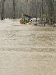 word-wrap:break-word'>